
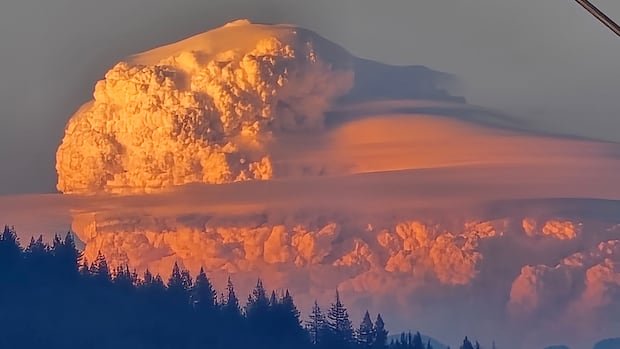
A massive blaze in the southwest region of France has given rise to the nation’s inaugural documented pyrocumulonimbus fire cloud. These unique clouds only manifest during significant wildfires and are typically observed in Canada during wildfire seasons, as evidenced by the recent occurrence during the Boston Bar fire in British Columbia.
Pyrocumulonimbus or pyroCb clouds are characterized as immense and cauliflower-shaped, visible from over 200 kilometers away. They often loom above dark smoke plumes, resembling the dark, fluffy cumulonimbus thunderstorm clouds from which they derive their name, incorporating “pyro” for “fire.” Initially forming as smaller pyrocumulus clouds reaching up to five kilometers in altitude, under the influence of extensive wildfires, they can evolve into pyroCb clouds, extending more than a dozen kilometers above ground level.
The genesis of these fire clouds stems from the heat generated by a wildfire, causing warm air to ascend in an updraft, carrying moisture, smoke, and burning embers along. As the atmosphere cools at higher altitudes, the vapor and smoke eventually cool and disperse, leading to the condensation of water into a cloud above the smoke column.
Although pyrocumulonimbus clouds are infrequent in Europe, they can manifest abundantly during North American wildfires, as noted by NASA. Meteorologist Mike Fromm from the Naval Research Lab in Washington, D.C. highlighted Canada as a focal point for pyrocumulonimbus occurrences globally.
The expansion of pyrocumulonimbus clouds can trigger thunderstorm-like behaviors, such as intense, unpredictable winds and lightning. These clouds have the potential to ascend high into the atmosphere, where freezing temperatures convert water droplets into ice, resulting in sudden downward air movements known as downdrafts. Moreover, the darkening effect of the clouds reduces visibility for firefighters and can create conditions akin to nighttime during the afternoon.
Despite their storm-like characteristics, these clouds do not typically yield significant rainfall due to the limited size of water droplets caused by smoke particles within them. The lightning generated by pyrocumulonimbus clouds can ignite new forest fires in previously unaffected areas, complicating fire suppression efforts and increasing the danger level.
Furthermore, pyrocumulonimbus clouds can disperse ash and smoke over vast distances by transporting them high into the lower stratosphere, enabling global dissemination and prolonged presence in the atmosphere. NASA reported that the monster pyroCb in British Columbia in 2021 produced nearly 113,000 cloud-to-ground lightning strikes, equivalent to approximately five percent of Canada’s annual lightning activity in a single event.

